
Four years ago, I wrote that “the importance of internet access cannot be overstated.” In 2022, the pandemic was still front and center in our minds, and the importance of reliable affordable internet was thrust into the spotlight. Many dollars and effort came together to try to rapidly improve internet infrastructure in unserved and underserved areas in Ohio. But the effort raised the consequential question, where exactly were these unserved and underserved areas? With a question so closely tied to geography, mapping played a critical role in finding answers. But maps can be misleading, or worse, deceiving. This is top of mind for me, as I recently made a broadband access map that, to be easily digestible, didn’t tell the full story.
Complex efforts to improve broadband in unserved and underserved areas
Governor DeWine created the office BroadbandOhio in early 2020, which among other things, was tasked in 2021 with developing a proposal to distribute nearly $800 million federal dollars through the Broadband, Equity, and Deployment (BEAD) program to unserved and underserved areas. According to BroadbandOhio, the final BEAD proposal was submitted last September, and approved in December by The National Telecommunications and Information Administration.
But where were those dollars going to be allocated?
The BEAD program has defined the technical parameters for what constitutes an unserved/underserved area, but the parameters rely on accurate testing and reporting of internet coverage and speeds.
The process of identifying these areas in need has been slow and flawed, and there are competing interests at play. For example, while states and local communities want to tap into these funds to build up affordable broadband infrastructure, internet service providers often want to show adequate coverage in a region to avoid competitors using these funds to build into “their" service territory. Similarly, if some providers claim that they already have a foothold in a region, they can make the case that they are the best suited to receive funding to enhance their existing infrastructure.
Competing claims about broadband gaps and delays
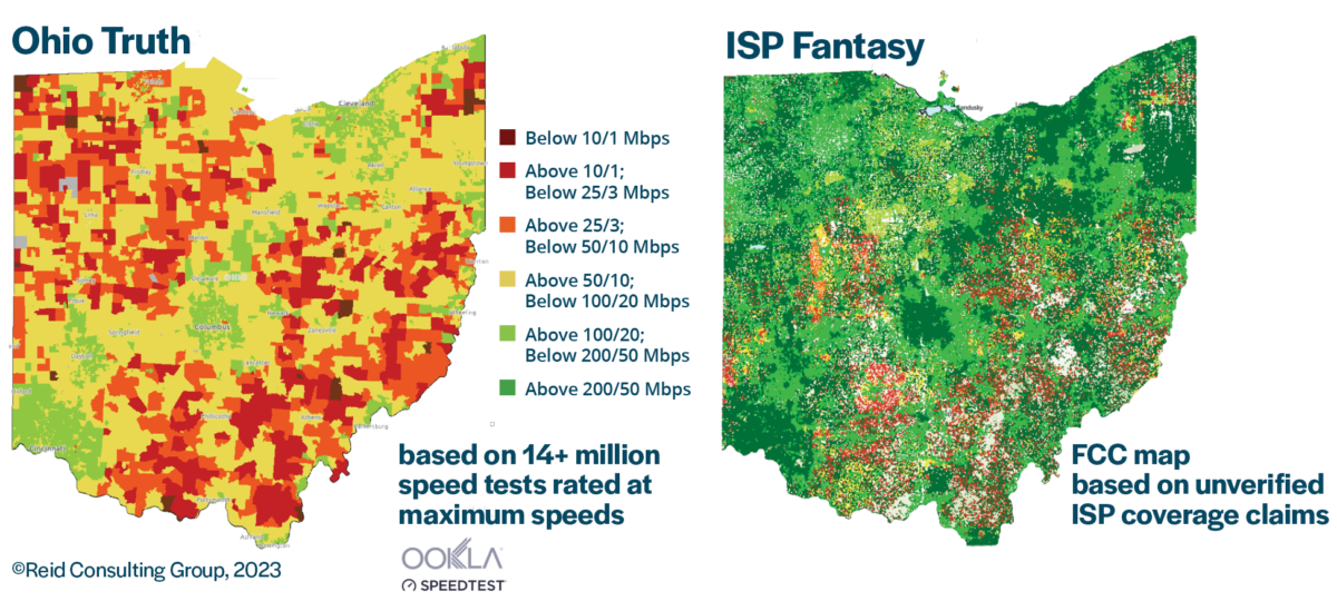
These competing interests are of note because, according to the Reid Consulting Group, “Broadband improvements have been constrained for decades by inaccurate maps, yet the Federal Communications Commission continues to accept dramatically exaggerated availability and capacity claims from internet service providers.” They go on to say disputing these maps (officially called a challenge process) is cumbersome and puts the burden on consumers and local governments to disprove the coverage maps.
BroadbandOhio contracted with the Reid Consulting Group in 2022 to build more accurate internet coverage maps for determining gaps in coverage. According to Lt. Governor Husted, these new maps were superior because they relied on “real-world, on-the-ground speed test information from actual internet customers,” as opposed to the FCC’s coverage maps that “only uses data that is reported through internet service providers.” The difference between the Federal Communications Commission and Reid Consulting Group’s coverage maps is stark, per the visual below created by Reid Consulting Group.
Broadband access increased in every Ohio county, 2019 – 2024...and yet
It is important to understand the role that mapping has played in the efforts to increase internet access. A few weeks ago, I wrote an article exploring changes in the state of Ohio mapping newly released census data. One of the many maps I made detailed the significant increase, from 2019-2024, in the percentage of households with broadband internet for every county in Ohio.
This is undeniably good news, but mapping this data at the county level tells an incomplete, and potentially misleading story. Whereas the FCC maps relied on potentially overexaggerated or outright faulty data, my original county level map relied on census data that was correct, but perhaps too broad to be particularly insightful. This was brought to my attention by a reader who noted that while access may have improved in her southern Ohio County, the rural parts of the county were still thoroughly disconnected from internet access.
This made sense to me, and I wanted to provide an update using the same newly released 2024 5-year American Community Survey data. To do this, I created three maps (below) that detail the percentage of households that reported not having a broadband subscription, broken out at the tract level.
Mapping this data at the county level tells an incomplete, and potentially misleading story. Census tracts are much more detailed than county-level data.
For example, 15 percent of households in Lawrence County reported not having broadband in their homes, a significant improvement from 26 percent in 2019. However, only looking at this data at the county level obfuscates the reality that in the northern part of the county, 39 percent of households in 2024 still don’t have broadband in their homes.
Three new broadband access maps by Census tracts
The first map highlights the differences by tract and the state average. The second map provides this data by income level, highlighting how in general lower income households are less likely to have a broadband subscription. The final map disaggregates this data by age, highlighting how older adults are less likely to have a broadband subscription.